NASA Sees Typhoon Pakhar Headed for Vietnam Landfall


The first typhoon of the northern hemisphere 2012 typhoon season is headed for landfall in Vietnam. NASA's Aqua and TRMM satellites have been providing forecasters with valuable data on Typhoon Pakhar, that includes rainfall rates, cloud extent and temperature.

The Tropical Rainfall Measuring Mission (TRMM) satellite flew almost directly over Pakhar when it was a newly formed tropical storm in the South China Sea on March 29, 2012 at 1122 UTC/4:22 p.m. Asia local time (or 7:22 a.m. EDT). The intensifying storm had wind speeds of about 45 knots (~52 mph/~83 kph) and was moving toward the west-northwest when viewed by this TRMM pass. A rainfall analysis used data from TRMM's Microwave Imager and Precipitation Radar (PR) instruments. It showed that moderate to heavy rainfall of about 35 mm/hr (~1.4 inches) was located in an area around Pakhar's southwestern side.

"TRMM's PR was used to create a 3-D image of Pakhar's structure and showed that some of the storms were reaching heights of about 13 kilometers (~8 miles) above the ocean surface," Hal Pierce of the TRMM satellite team at NASA's Goddard Space Flight Center in Greenbelt, Md. where the images were created.

The Moderate Resolution Imaging Spectroradiometer (MODIS) instrument on NASA's Terra satellite captured a true-color image of Typhoon Pakhar on March 30, 2012 at 03:20 UTC/10:20 a.m. Asia local time (March 29 at 11:20 p.m. EDT) moving through the South China Sea toward Vietnam. Bands of thunderstorms are tightly wrapped around the center of Pakhar's center, and there may be an eye forming, but it is covered by dense overcast in MODIS visible imagery.

Icy Moons through Cassini's Eyes


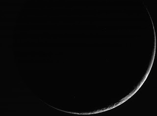
These raw, unprocessed images of Saturn's moons Enceladus, Janus and Dione were taken on March 27 and 28, 2012, by NASA's Cassini spacecraft.

Cassini passed Enceladus first on March 27, coming within about 46 miles (74 kilometers) of the moon's surface. The encounter was primarily designed for Cassini's ion and neutral mass spectrometer, which "tasted" the composition of Enceladus' south polar plume. Other instruments, including the Cassini plasma spectrometer and composite infrared spectrometer, also took measurements.

Before the closest approach of this encounter, Cassini's cameras imaged the plume, which is comprised of jets of water ice and vapor, and organic compounds emanating from the south polar region. Later, the cameras captured a nine-frame mosaic of the surface of the moon's leading hemisphere as the spacecraft left the moon.

After the Enceladus encounter, Cassini passed the small moon Janus with a closest approach distance of 27,000 miles (44,000 kilometers). The planet was in the background in some of these views.

Early on March 28, the spacecraft flew by Dione at a distance of 27,000 miles (44,000 kilometers) and collected, among other observations, a nine-frame mosaic depicting the side of the moon that faces away from Saturn in its orbit.

NASA GRACE Data Hit Big Apple on World Water Day


To highlight declines in the world's groundwater supplies, a new visualization of Earth's groundwater reserves, created in part with space data from the joint NASA/German Aerospace Center (DLR) Gravity Recovery and Climate Experiment (GRACE) mission, debuted on New York's Times Square on March 22, International World Water Day.

The 30-second animation, titled "Visualizing Seasonal and Long-term Changes in Groundwater Levels," will be on display several times each hour through April 22 on Times Square's massive Thomson Reuters and NASDAQ digital signboards. Viewers of the interactive animation are invited to use their mobile devices to submit their city and add a graph to the sign.

Netherlands designer Richard Vijgen developed the animation using GRACE data analyzed by professor Jay Famiglietti, director of the UC Center for Hydrologic Modeling at the University of California, Irvine; and from United States Geological Survey data supplied by Leonard Konikow. Vijgen was the winning entry in an international design visualization competition sponsored by the organization HeadsUP!, in collaboration with Visualizing.org. Founded by digital media artist Peggy Weil, HeadsUp! challenges designers to visualize critical global issues and create a shared sign for the public square.

Groundwater is a critical, but often overlooked, natural resource. According to a U.N. report, more than 1.5 billion people around the world depend on groundwater for their drinking water. It comes from the natural percolation of precipitation and other surface waters down through Earth's soil and rock, accumulating in cavities and layers of porous rock, gravel, sand or clay. Groundwater levels respond slowly to changes in weather and can take months or years to replenish once pumped for irrigation or other uses.

NASA Flight Tests New ADS-B Device on Ikhana UAS

NASA's Dryden Flight Research Center flew its Ikhana MQ-9 unmanned aircraft with an Automatic Dependent Surveillance-Broadcast, or ADS-B, device, for the first time on March 15.

It was the first time an unmanned aircraft as large as Ikhana with a 66-foot wingspan, a takeoff weight of more than 10,000 pounds, and a cruising altitude of 40,000 feet has flown while equipped with ADS-B. ADS-B is an aircraft tracking technology that all planes operating in certain U.S. airspace must adopt by January 2020 to comply with Federal Aviation Administration (FAA) regulations.

It also was the first flight of hardware for the NASA Aeronautics research project known as UAS in the NAS, which is short for Unmanned Aircraft Systems Integration in the National Airspace System.

The equipment performed well during a flight lasting nearly three hours in restricted air space over Dryden's Western Aeronautical Test Range, which is part of Edwards Air Force Base and the China Lake Naval Air Warfare Center.

Being equipped with ADS-B enables NASA's Ikhana to provide much more detailed position, velocity, and altitude information about itself to air traffic controllers, airborne pilots of other ADS-B equipped aircraft flying in its vicinity, and to its pilots on the ground. Currently, only air traffic controllers can see all the aircraft in any given section of the sky.

Introducing the X-56A MUTT: Who Let the Dog Out?

NASA's Dryden Flight Research Center soon will have a new dog in the yard, and it's a real MUTT. That's short for the Multi-Use Technology Testbed, a small unmanned aircraft being developed by the U.S. Air Force Research Laboratory to test technologies that will be needed for new kinds of lightweight, flexible aircraft.

MUTT is one of the Air Force's newest X-planes, designated X-56A. The 7.5-foot-long aircraft has a 28-foot wingspan and will be powered by two 52-pound thrust JetCat P200-SX turbine engines. It is being built in California under contract to Lockheed Martin Corp., which will conduct the flight experiments for the Air Force Research Laboratory (AFRL).

Dryden will oversee the flights for AFRL during summer 2012, and then take ownership of the X-56A MUTT for follow-on research after the Air Force tests are finished in early autumn.

“Flexible wings and fuselages can result in significant reductions in the structural weight of aircraft,” says Gary Martin, deputy project manager for NASA's Subsonic Fixed Wing Project at Dryden.

But unlike the short, stiff wings found on most aircraft today, long, thin wings like those on the X-56A are susceptible to uncontrollable vibrations, called flutter, that result from the force of air flowing over them. Thin wings can also be stressed by bending forces from wind gusts and atmospheric turbulence.

Hubble Sees Glittering Jewels of Messier 9


The NASA/ESA Hubble Space Telescope has produced the most detailed image so far of Messier 9, a globular star cluster located close to the center of the galaxy. This ball of stars is too faint to see with the naked eye, yet Hubble can see over 250,000 individual stars shining in it.

Messier 9, pictured here, is a globular cluster, a roughly spherical swarm of stars that lies around 25,000 light-years from Earth, near the centre of the Milky Way, so close that the gravitational forces from the galactic centre pull it slightly out of shape.

Globular clusters are thought to harbor some of the oldest stars in our galaxy, born when the Universe was just a small fraction of its current age. As well as being far older than the sun around twice its age the stars of Messier 9 also have a markedly different composition, and are enriched with far fewer heavier elements than the sun.

In particular, the elements crucial to life on Earth, like oxygen and carbon, and the iron that makes up our planet’s core, are very scarce in Messier 9 and clusters like it. This is because the universe’s heavier elements were gradually formed in the cores of stars, and in supernova explosions. When the stars of Messier 9 formed, there were far smaller quantities of these elements in existence.

Science Nugget: Modeling Extreme Space Weather


Explosions on the sun regularly disrupt the magnetic envelope surrounding Earth, but that envelope, the magnetosphere, largely protects the surface of the planet itself from space weather with one exception. As a rule, changes in magnetic fields cause electric currents and vice versa, so all that change in the magnetosphere causes electric currents to form on the ground. Called geomagnetically induced currents or GICs, such currents extend some 60 miles underground, electrifying any conductors – power grid lines, or oil pipes, for example along the way.

A big enough electrical surge from a GIC can knock out the transformers in a power grid. Electric companies can protect the grid from such surges by shutting down or lowering the power load on the system, but this, of course, costs money so they also don't wish to be overly cautious by reducing power output unless it is really necessary. New analysis by scientists at NASA's Goddard Space Flight Center in Greenbelt, Md., published online in Space Weather on February 23, 2012, provides some basic guidelines to help model some of the largest, most damaging GICs.

Risk analysis and adequate risk protection both rely on numerous factors. Modeling an extreme, devastating GIC is a crucial part of that picture. Referred to as 100-year events, that is, events so extreme they only happen on average once every 100 years, such currents could cause significant damage to Earth's power grids worldwide. But proper preparation and accurate space weather forecasting could mitigate intense damage, the same way that communities can evacuate or protect their homes if given enough advance warning of a hurricane.

Cassini Plasma Spectrometer Resumes Operations


PASADENA, Calif. The Cassini plasma spectrometer instrument (CAPS) aboard NASA's Cassini spacecraft at Saturn has resumed operations. Mission managers received confirmation on Friday, March 16, that it was turned on. They plan to monitor the instrument for any unusual behavior.

Last June, short circuits in the instrument led to unexpected voltage shifts on the spacecraft. As a precaution, mission managers turned off the CAPS instrument while engineers investigated the issue. The investigation led to the conclusion that tin plating on electronics components had grown "whiskers." The whiskers were very small, less than the diameter of a human hair, but they were big enough to contact another conducting surface and carry electrical current. Researchers are still trying to understand why whiskers grow on tin and other metals, but they know now that whiskers can grow in space and on Earth. It is believed that these or additional tin whiskers that may grow on Cassini cannot carry enough current to cause problems, but will burn out on their own like a lightweight fuse.

Cassini launched in 1997 and has been exploring the Saturn system since 2004. The project completed its original prime mission in 2008 and has been extended twice. Cassini is now in its solstice mission, which will enable scientists to observe seasonal change in the Saturn system through the northern summer solstice.

The Cassini-Huygens mission is a cooperative project of NASA, the European Space Agency and the Italian Space Agency. The Jet Propulsion Laboratory, a division of the California Institute of Technology in Pasadena, manages the mission for NASA's Science Mission Directorate, Washington.

Cassini Garners Top Honor From Air and Space Museum


PASADENA, Calif. NASA's Cassini mission to Saturn, managed by the Jet Propulsion Laboratory, Pasadena, Calif., has received the top group honor from the Smithsonian's National Air and Space Museum the Trophy for Current Achievement. Representatives for Cassini will receive the trophy on March 21 at a black-tie dinner in Washington, D.C.

"Here we are some 15 years since Cassini launched and it's amazing how well the spacecraft has operated," said Charles Elachi, director of JPL. "Thanks to the superb work of both the development team and the operations team, Cassini has been able to show us the beauty and diversity of the Saturn system and, beyond that, to study what is really a miniature solar system in its own right."

The trophies for current and lifetime achievement are the National Air and Space Museum's most prestigious awards. They recognize outstanding achievements in the fields of aerospace science, technology and their history.

"The National Air and Space Museum Trophy is among the most prestigious awards given by the Smithsonian, it recognizes significant aerospace accomplishments," said National Air and Space Museum Director Jack Dailey. "We are pleased to present it to the Cassini-Huygens Flight Team in the Current Achievement category."

The Cassini-Huygens mission, a cooperative project of NASA, the European Space Agency and the Italian Space Agency, launched in 1997. It performed a dramatic burn in June 2004 to slide into orbit around Saturn and, in December of that year, the spacecraft successfully released ESA's Huygens probe to pass down through the atmosphere of Saturn's largest moon Titan.

Astronomers Using NASA's Hubble Discover Quasars Acting as Gravitational Lenses


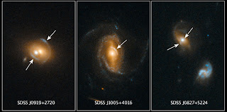
Astronomers using NASA's Hubble Space Telescope have found several examples of galaxies containing quasars, which act as gravitational lenses, amplifying and distorting images of galaxies aligned behind them.

Quasars are among the brightest objects in the universe, far outshining the total starlight of their host galaxies. Quasars are powered by supermassive black holes.

To find these rare cases of galaxy-quasar combinations acting as lenses, a team of astronomers led by Frederic Courbin at the Ecole Polytechnique Federale de Lausanne (EPFL, Switzerland) selected 23,000 quasar spectra in the Sloan Digital Sky Survey (SDSS). They looked for the spectral imprint of galaxies at much greater distances that happened to align with foreground galaxies. Once candidates were identified, Hubble's sharp view was used to look for gravitational arcs and rings (which are indicated by the arrows in these three Hubble photos) that would be produced by gravitational lensing.

Quasar host galaxies are hard or even impossible to see because the central quasar far outshines the galaxy. Therefore, it is difficult to estimate the mass of a host galaxy based on the collective brightness of its stars. However, gravitational lensing candidates are invaluable for estimating the mass of a quasar's host galaxy because the amount of distortion in the lens can be used to estimate a galaxy's mass.

The next step for the team is to build a catalog of "quasar-lenses" that will allow them to determine masses for a statistically significant number of quasar host galaxies and to compare them with galaxies without quasars. With the numerous wide-field surveys that will start in the near future or that are already started, hundreds of thousands of quasars will be accessible for looking for lensing effects.

Flying Through a Geomagnetic Storm


Glowing green and red, shimmering hypnotically across the night sky, the aurora borealis is a wonder to behold. Longtime sky watchers say it is the greatest show on Earth.

It might be the greatest show in Earth orbit, too. High above our planet, astronauts onboard the International Space Station (ISS) have been enjoying an up-close view of auroras outside their windows as the ISS flys through geomagnetic storms.

"We can actually fly into the auroras," says eye-witness Don Pettit, a Flight Engineer for ISS Expedition 30. "It's like being shrunk down and put inside of a neon sign."

Auroras are caused by solar activity. Gusts of solar wind and coronal mass ejections strike Earth's magnetic field, rattling our planet's protective shell of magnetism. This causes charged particles to rain down over the poles, lighting up the atmosphere where they hit. The physics is akin to what happens in the picture tube of a color TV.

Incoming particles are guided by Earth's magnetic field to a pair of doughnut-shaped regions called "auroral ovals." There's one around the North Pole and one around the South. Sometimes, when solar activity is high, the ovals expand, and the space station orbits right through them.

Storms From the Sun

Space weather starts at the sun. It begins with an eruption such as a huge burst of light and radiation called a solar flare or a gigantic cloud of solar material called a coronal mass ejection (CME). But the effects of those eruptions happen at Earth, or at least near-Earth space. Scientists monitor several kinds of space "weather" events geomagnetic storms, solar radiation storms, and radio blackouts all caused by these immense explosions on the sun.

One of the most common forms of space weather, a geomagnetic storm refers to any time Earth's magnetic environment, the magnetosphere, undergoes sudden and repeated change. This is a time when magnetic fields continually re-align and energy dances quickly from one area to another.


Geomagnetic storms occur when certain types of CMEs connect up with the outside of the magnetosphere for an extended period of time. The solar material in a CME travels with its own set of magnetic fields. If the fields point northward, they align with the magnetosphere's own fields and the energy and particles simply slide around Earth, causing little change. But if the magnetic fields point southward, in the opposite direction of Earth's fields, the effects can be dramatic. The sun's magnetic fields peel back the outermost layers of Earth's fields changing the whole shape of the magnetosphere. This is the initial phase of a geomagnetic storm.

The next phase, the main phase, can last hours to days, as charged particles sweeping into the magnetosphere accumulate more energy and more speed. These particles penetrate closer and closer to the planet. During this phase viewers on Earth may see bright aurora at lower latitudes than usual. The increase and lower altitude of radiation can also damage satellites traveling around Earth.

Citizen Scientists Reveal a Bubbly Milky Way

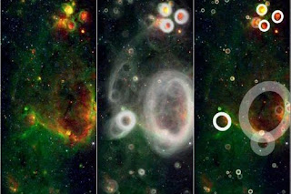
A team of volunteers has pored over observations from NASA's Spitzer Space Telescope and discovered more than 5,000 "bubbles" in the disk of our Milky Way galaxy. Young, hot stars blow these bubbles into surrounding gas and dust, indicating areas of brand new star formation.

Upwards of 35,000 "citizen scientists" sifted through the Spitzer infrared data as part of the online Milky Way Project to find these telltale bubbles. The volunteers have turned up 10 times as many bubbles as previous surveys so far.

"These findings make us suspect that the Milky Way is a much more active star-forming galaxy than previously thought," said Eli Bressert, an astrophysics doctoral student at the European Southern Observatory, based in Germany, and the University of Exeter, England, and co-author of a paper submitted to the Monthly Notices of the Royal Astronomical Society.

"The Milky Way's disk is like champagne with bubbles all over the place," he said.

Computer programs struggle at identifying the cosmic bubbles. But human eyes and minds do an excellent job of noticing the wispy arcs of partially broken rings and the circles-within-circles of overlapping bubbles. The Milky Way Project taps into the "wisdom of crowds" by requiring that at least five users flag a potential bubble before its inclusion in the new catalog. Volunteers mark any candidate bubbles in the infrared Spitzer images with a sophisticated drawing tool before proceeding to scour another image.

"The Milky Way Project is an attempt to take the vast and beautiful data from Spitzer and make extracting the information a fun, online, public endeavor," said Robert Simpson, a postdoctoral researcher in astronomy at Oxford University, England, principal investigator of the Milky Way Project and lead author of the paper.

Dark Matter Core Defies Explanation

Astronomers using data from NASA's Hubble Telescope have observed what appears to be a clump of dark matter left behind from a wreck between massive clusters of galaxies. The result could challenge current theories about dark matter that predict galaxies should be anchored to the invisible substance even during the shock of a collision.

Abell 520 is a gigantic merger of galaxy clusters located 2.4 billion light-years away. Dark matter is not visible, although its presence and distribution is found indirectly through its effects. Dark matter can act like a magnifying glass, bending and distorting light from galaxies and clusters behind it. Astronomers can use this effect, called gravitational lensing, to infer the presence of dark matter in massive galaxy clusters.

This technique revealed the dark matter in Abell 520 had collected into a "dark core," containing far fewer galaxies than would be expected if the dark matter and galaxies were anchored together. Most of the galaxies apparently have sailed far away from the collision.

"This result is a puzzle," said astronomer James Jee of the University of California in Davis, lead author of paper about the results available online in The Astrophysical Journal. "Dark matter is not behaving as predicted, and it's not obviously clear what is going on. It is difficult to explain this Hubble observation with the current theories of galaxy formation and dark matter."

NASA Researchers on the Snow Patrol


The sky is gray. It's cold. Three forecast models predicted snow. It's 9:20 pm. Gail Skofronick-Jackson looks out the window of the operations trailer where she and her colleagues are running the Global Precipitation Measurement (GPM) mission's Cold-season Precipitation Experiment (GCPEx). The DC-8 research plane circles overhead, ready to measure the snowfall.

There's nothing. The sky is still gray. It's still cold. The operations trailer sits in the middle of a field in Egbert, Ontario, Canada where it's surrounded by an acre of scientific instruments, all still, waiting.

It's 10:20 pm. The sky is a darker shade of gray. The night is colder. The science team has blank screens showing no active falling snow and a big case of boredom. There's still nothing. They send the DC-8 back to its hanger and pack it in.

"If the models and forecasts were correct we wouldn't be out here," says Skofronick-Jackson. She's the GPM Deputy Project Scientist and a specialist in the remote sensing of snow at NASA's Goddard Space Flight Center, Greenbelt, Md. In running GCPEx, she and the team are attempting to simulate the snow measurements that will be made by the GPM satellite mission that launches 2014. They do that by gathering snow data with instruments on the ground and aboard aircraft that fly through and over snowstorms.

But to collect data on snow, it has to snow.

Even without high-tech NASA instruments, snow is challenging to measure. Ground measurements are plagued by blowing snow and inconsistent methods, and snow tends to be geographically spotty.

NASA Finds Sea Ice Driving Arctic Air Pollutants


PASADENA, Calif. Drastic reductions in Arctic sea ice in the last decade may be intensifying the chemical release of bromine into the atmosphere, resulting in ground-level ozone depletion and the deposit of toxic mercury in the Arctic, according to a new NASA-led study.

The connection between changes in the Arctic Ocean's ice cover and bromine chemical processes is determined by the interaction between the salt in sea ice, frigid temperatures and sunlight. When these mix, the salty ice releases bromine into the air and starts a cascade of chemical reactions called a "bromine explosion." These reactions rapidly create more molecules of bromine monoxide in the atmosphere. Bromine then reacts with a gaseous form of mercury, turning it into a pollutant that falls to Earth's surface.

Bromine also can remove ozone from the lowest layer of the atmosphere, the troposphere. Despite ozone's beneficial role blocking harmful radiation in the stratosphere, ozone is a pollutant in the ground-level troposphere.

A team from the United States, Canada, Germany, and the United Kingdom, led by Son Nghiem of NASA's Jet Propulsion Laboratory in Pasadena, Calif., produced the study, which has been accepted for publication in the Journal of Geophysical Research- Atmospheres. The team combined data from six NASA, European Space Agency and Canadian Space Agency satellites; field observations and a model of how air moves in the atmosphere to link Arctic sea ice changes to bromine explosions over the Beaufort Sea, extending to the Amundsen Gulf in the Canadian Arctic.

Antlia Dwarf Galaxy Peppers the Sky with Stars


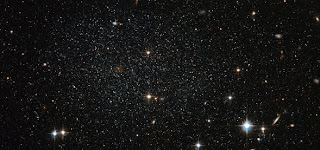
The myriad faint stars that comprise the Antlia Dwarf galaxy are more than four million light-years from Earth, but this NASA/ESA Hubble Space Telescope image offers such clarity that they could be mistaken for much closer stars in our own Milky Way. This very faint and sparsely populated small galaxy was only discovered in 1997.

This image was created from observations in visible and infrared light taken with the Wide Field Channel of Hubble’s Advanced Camera for Surveys. The field of view is approximately 3.2 by 1.5 arcminutes.

Although small, the Antlia Dwarf is a dynamic site featuring stars at many different stages of evolution, from young to old. The freshest stars are only found in the central regions where there is significant ongoing star formation. Older stars and globular clusters are found in the outer areas.

It is not entirely clear whether the Antlia Dwarf is a member our galactic neighborhood, called the Local Group. It probably lies just beyond the normally accepted outer limits of the group. Although it is fairly isolated, some believe it has interacted with other star groups. Evidence comes from galaxy NGC 3109, close to the Antlia Dwarf (but not visible in this image). Both galaxies feature rifts of stars moving at comparable velocities; a telltale sign that they were gravitationally linked at some point in the past.

Camera on NASA Mars Odyssey Tops Decade of Discovery


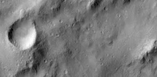
Ten years ago, on Feb. 19, 2002, the Thermal Emission Imaging System (THEMIS), a multi-band camera on NASA's Mars Odyssey orbiter, began scientific operations at the Red Planet. Since then the camera has circled Mars nearly 45,000 times and taken more than half a million images at infrared and visible wavelengths.

"THEMIS has proven itself a workhorse," said Philip Christensen of Arizona State University, Tempe, the camera's principal investigator and designer. "It's especially gratifying to me to see the range of discoveries that have been made using this instrument."

Highlights of science results by THEMIS over the past 10 years include:

* Confirming a mineral exposure selected as the landing site for NASA's Mars Exploration Rover Opportunity

* Discovering carbon-dioxide gas jets at the south polar ice cap in spring

* Discovering chloride salt deposits across the planet

* Making the best global image map of Mars ever done

* Identifying safe landing sites landing sites for NASA's Mars Phoenix lander by finding the locations with the fewest hazardous boulders

* Monitoring dust activity in the Martian atmosphere

* Discovering that a large crater, Aram Chaos, once contained a lake

* Discovering that Mars has more water-carved channels than previously thought

* Discovering dacite on Mars, a more evolved form of volcanic lava not previously known on the Red Planet

THEMIS combines a five-wavelength visual imaging system with a nine-wavelength infrared imaging system. By comparing daytime and nighttime infrared images of an area, scientists can determine many of the physical properties of the rocks and soils on the ground.

Mars Odyssey has a two-hour orbit that is nearly "sun-synchronous," meaning that Odyssey passes over the same part of Mars at roughly the same local time each day. In September 2008 its orbit was shifted toward an earlier time of day, which enhanced THEMIS' mineralogical detection capability.